Project area
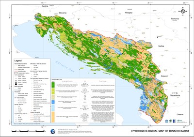
The project area consists of karst areas in the four project countries (Albania, Bosnia and Herzegovina, Croatia and Montenegro) and covers most of the Dinaric mountain chain or Dinaric Alps. Named after Dinara mountain in Croatia and Bosnia and Herzegovina, Dinaric Alps stretches (in several separate mountain ranges) from southern edges of the Eastern Alps in Slovenia and Italy further across the western side of the Balkan peninsula, NE of the Adriatic Sea and south of Sava river basin in Pannonian plain, until it touches the westernmost parts of the old Rhodope mountains in central and southern Serbia, and reaches Pindus mountain chain in northern Albania and Sara mountain system near Kosovo, on its SE end along the Drin river. The most southern part of Dinaric mountain chain is in Albania denoted as Albanian Alps.
Hydrogeological map of the Dinaric Karst (click to enlarge)
Almost all the islands in the eastern Adriatic (as well as all the mountains rising behind the well indented coasts of Croatia and Montenegro) belong to this mountain system because the western parts of the chain were partially submerged by the seawater in earlier geological history. The term Dinaric Karst Aquifer System has been used in this project to emphasize uniqueness and interconnectivity of groundwater in the region.


